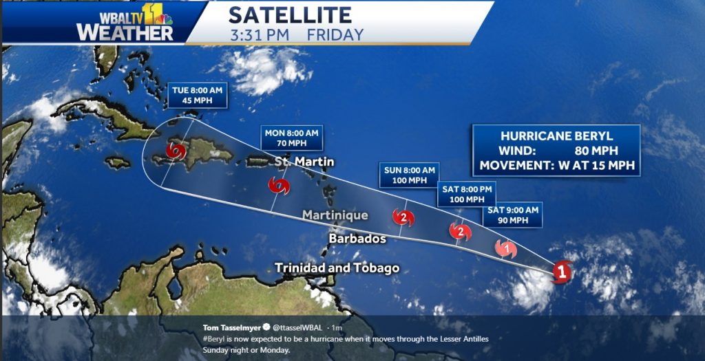

WATCHES AND WARNINGS
--------------------
There are no coastal watches or warnings in effect.

Interests in the Lesser Antilles should monitor the progress of #Beryl, as hurricane watches could be needed for some of the islands by tonight.


DISCUSSION AND OUTLOOK
----------------------
At 1100 AM AST (1500 UTC), the eye of Hurricane Beryl was located near latitude 10.7 North, longitude 46.5 West.  #Beryl is moving toward the west near 15 mph (24 km/h).  A faster westward to
west-northwestward motion is expected to begin over the weekend and continue through early next week.  On the forecast track, the center of Beryl will approach the Lesser Antilles over the weekend
and cross the island chain late Sunday or Monday.

Maximum sustained winds have increased to near 80 mph (130 km/h) with higher gusts.  Additional strengthening is forecast during the next couple of days, and Beryl is expected to still be a hurricane
when it reaches the Lesser Antilles late Sunday or Monday.
Weakening is expected once Beryl reaches the eastern Caribbean Sea on Monday, but the system may not degenerate into an open trough until it reaches the vicinity of Hispaniola and the central
Caribbean Sea.

Beryl is a compact hurricane.  Hurricane-force winds extend outward up to 10 miles (20 km) from the center, and tropical-storm-force winds extend outward up to 35 miles (55 km).

The estimated minimum central pressure is 994 mb (29.36 inches). (editor note - no USA impact expected. Puerto Rico region may be affected)


HAZARDS AFFECTING LAND
----------------------
None. Image Tom Tasselmyer WBAL @ttasselwbal

Be the first to comment on "Hurricane Beryl Steams West from Atlantic"